Skip to content
Ashland Forest Resiliency Stewardship Project
  • About
    • 10 Year Celebration! Story Map
    • Accomplishments
    • Factsheets
    • Interpretive Signs and Hiking Maps
    • News
    • Partners and Roles
    • Videos & Images
    • Work Update
  • What We Do
    • Controlled Burns
    • Why We Burn
    • Education
    • Landowner Grants
    • Restoration
  • Be Informed
    • Factsheets
    • Maps
    • News
    • Receive Alerts
    • Trail Information
    • Watershed Camera
  • Join Us
    • Contact Us
    • Events
    • Receive Alerts
  • Science
    • Implementation Monitoring
    • Social Monitoring
    • University Research
    • Vegetation Monitoring
    • Water
    • Wildlife
×
  • About
    • 10 Year Celebration! Story Map
    • Accomplishments
    • Factsheets
    • Interpretive Signs and Hiking Maps
    • News
    • Partners and Roles
    • Videos & Images
    • Work Update
  • What We Do
    • Controlled Burns
    • Why We Burn
    • Education
    • Landowner Grants
    • Restoration
  • Be Informed
    • Factsheets
    • Maps
    • News
    • Receive Alerts
    • Trail Information
    • Watershed Camera
  • Join Us
    • Contact Us
    • Events
    • Receive Alerts
  • Science
    • Implementation Monitoring
    • Social Monitoring
    • University Research
    • Vegetation Monitoring
    • Water
    • Wildlife
Ashland Forest Resiliency Stewardship Project
×
  • About
    • 10 Year Celebration! Story Map
    • Accomplishments
    • Factsheets
    • Interpretive Signs and Hiking Maps
    • News
    • Partners and Roles
    • Videos & Images
    • Work Update
  • What We Do
    • Controlled Burns
    • Why We Burn
    • Education
    • Landowner Grants
    • Restoration
  • Be Informed
    • Factsheets
    • Maps
    • News
    • Receive Alerts
    • Trail Information
    • Watershed Camera
  • Join Us
    • Contact Us
    • Events
    • Receive Alerts
  • Science
    • Implementation Monitoring
    • Social Monitoring
    • University Research
    • Vegetation Monitoring
    • Water
    • Wildlife

Maps

Click on the Controlled burn map to see locations where the Ashland Forest Resiliency is conducting controlled burning.

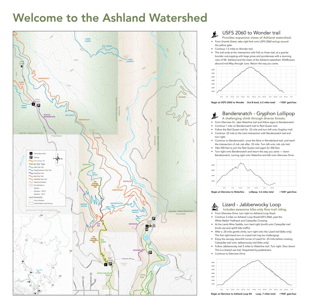
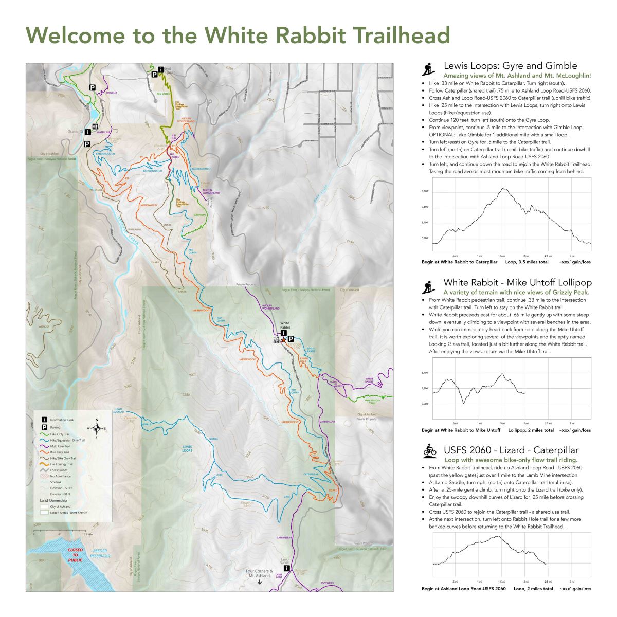
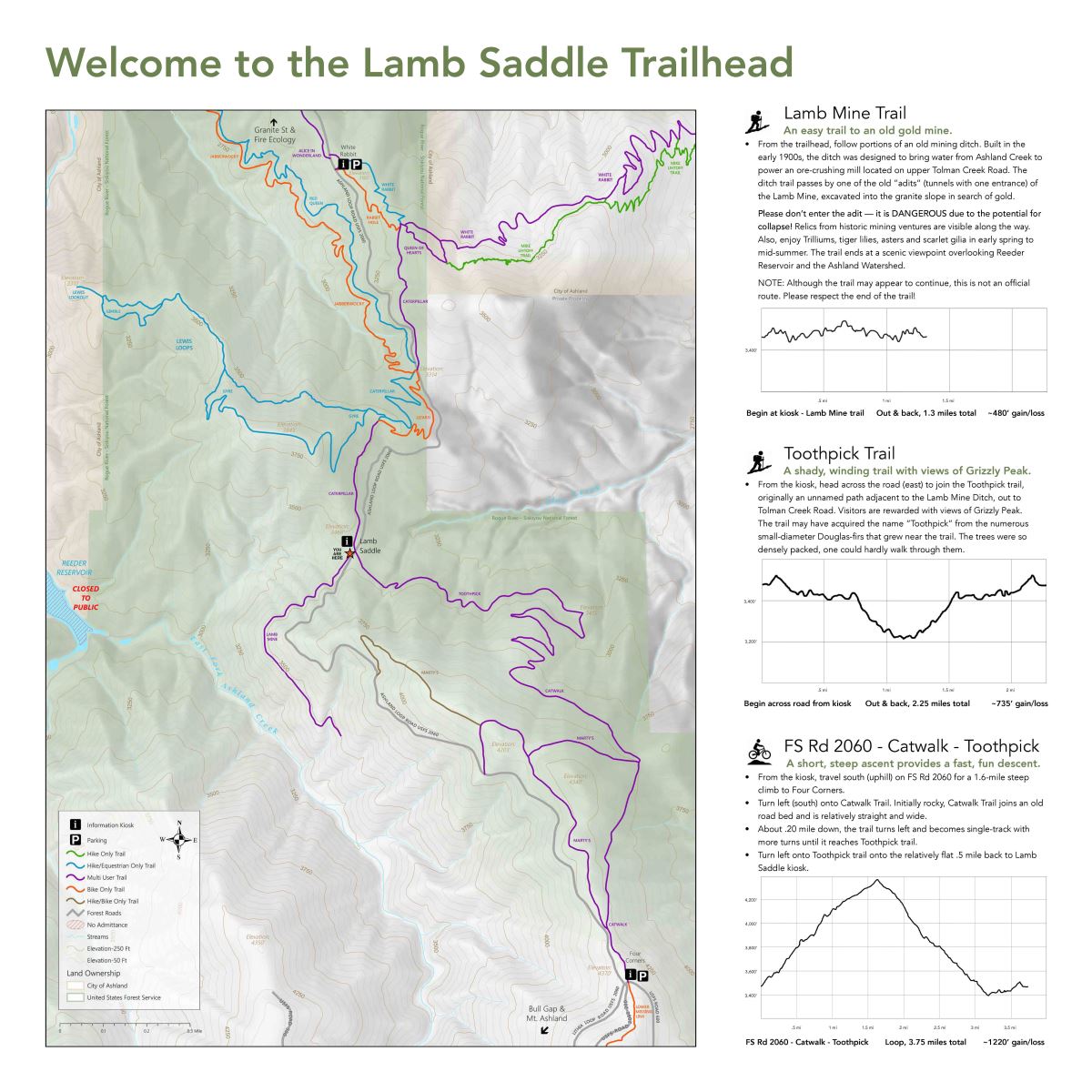
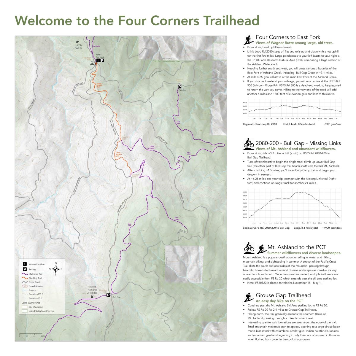
Trail Maps - Click on Maps to View/Download the .PDF

Granite Reservoir

Interpretive Signs and Hiking Maps

White Rabbit

Interpretive Signs and Hiking Maps

Lamb Saddle

Interpretive Signs and Hiking Maps

Four Corners

Interpretive Signs and Hiking Maps

Click here and scroll down to "AFR Maps" to view the trails on City property and Forest Service lands in the Ashland Watershed.

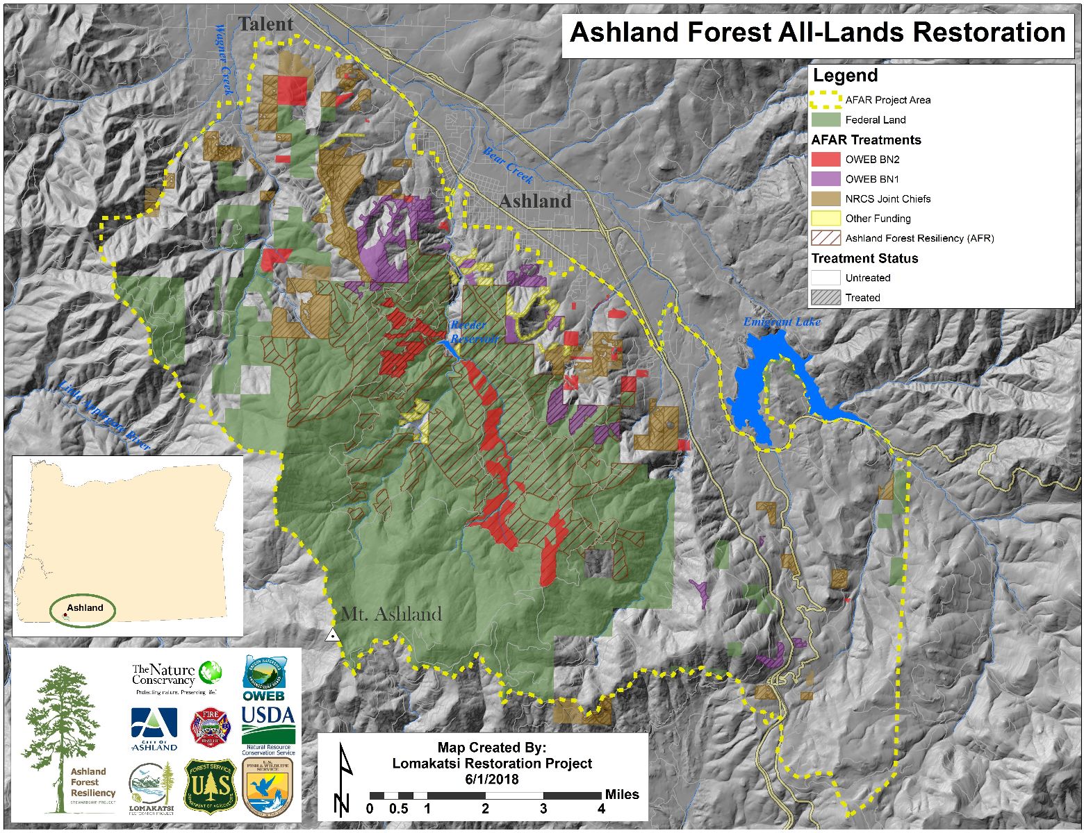
Ashland Forest Resiliency Project Map

Ashland Forest All-Lands Restoration
Connect With Us

City Source Newsletter

Sign Up
Connect With Us

Community Alerts

Sign Up
Connect With Us

Department Directory

View Directory

Email Updates

Sign up to receive weekly updates of News & Events

Please enter your name.
Please enter a valid email address.
Subscribe!
Something went wrong. Please check your entries and try again.
Accessibility Assistance

© 2022 City of Ashland. All Rights Reserved.
Site Handcrafted in Ashland, Oregon by Project A

Search
Scroll To Top